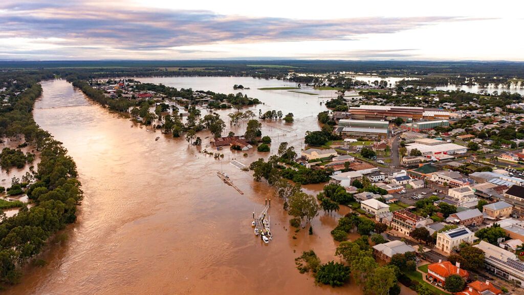
Brisbane is hot and sultry in the early months of the year. Humid. Our bodies cope by perspiring, or in these modern times, turning on the air conditioner. So we welcome the afternoon thunderstorms which refresh the land and the mood, before it turns sultry again. Well, mostly. Very once in a while the rain gets so heavy that it puts Brisbane in harms way as a swollen, angry river rips through its heart.
And while this may be a nuisance or worse to Brisbanites, the Brisbane River system predates people. It is around 40 million years old, and the river settled into its present course about 10 million years ago.
Since these pre-historic days and certainly from the moment it was charted by European explorers in the 1820s, its ebb and flow have shaped the land, the settlement, and the psyche of its inhabitants. An Indigenous dreamtime story – the river is known as Maiwar to the Yuggera and Turban peoples – tells how the Brisbane River was created. It tells how Moodagurra, the rainbow serpent, became stuck as she made her way up a dry creek. Moodagurra called on Yara (the rain) and Ngalan (the cloud) to help her out of her predicament. As the storm thundered and rain flowed into the creek, the water seeped under Moodagurra’s belly, allowing her to wriggle from side to side. This movement created the sinuous Maiwar. Now, folklore suggests, Moodagurra decides when the big rains come.
The river gave life and trade, but it also bore wrathful floods: sudden, deep, devastating, unevenly distributed in time, yet happening often enough to be always somewhere in the back of mind. To understand Brisbane is to understand this push and pull — the fertile plains beside the river, the calamitous flooding of low-lying suburbs, and the enduring spirit of a city forever negotiating with water.
Indigenous oral histories speak of floods beyond recorded gauges — great surges of water that submerged the countryside long before colonial settlement and before the British charted the region. In these stories, water was not to be dominated as successive colonial engineers attempted to do, but rather it was a force to respect — part of seasonal rhythms that governed movement, food and ceremony.
The first officially recorded flood in Brisbane came in the early colonial era. By the 1840s, mostly British settlers — unfamiliar with sub-tropical rainfall patterns and monsoon cycles — began to document rises in the Brisbane River that overwhelmed the limited infrastructure of a burgeoning town. On 14th January 1841, the river level reached 8.43 metres above the low tide mark — still the highest recorded in the city gauge’s official history. Waters submerged farmland and low structures, foreshadowing the destruction of future storms. Just three years later, on 10th January 1844, the river rose again to more than seven metres, removing any doubts that floods were aberrations. They seemed to be regular events in the sub-tropical climate and topography of south east Queensland.
Throughout the mid-19th century, floods continued with varying severity — in 1863, 1864, and repeated episodes in 1857 and 1870, waters would sweep through the lower reaches of the city and neighbouring Ipswich, stretching the fledgling settlement’s capacity to respond. These early floods did not yet make headlines in the way later catastrophes would, but they established patterns: heavy summer rainfall, swelling tributaries, and waters breaking their banks across the plains.
If there is one episode that crystallised Brisbane’s flood heritage — the benchmark against which all later events have been measured — it is the 1893 floods. That year, Queensland endured a very wet summer linked to what we know now as a strong La Niña pattern. The region was belted by torrential rain, particularly in February. In quick order, the river surged three times. On the 6th February, the first flood began, triggered by a deluge driven by a nearby tropical cyclone. On the 11th February, more rains caused another rise. Then, on 19th February, waters swelled again in a third devastating crest.
The consequences were staggering: the Brisbane River broke its banks, inflating a watery landscape that submerged streets, homes, wharves, sheds, and businesses. The Port Office gauge recorded flood heights of 8.35 metres and 8.09 metres — eclipsed only slightly by the levels reached in 1841 flood. In the downtown area, water lapped verandah roofs; in South Brisbane, entire blocks vanished beneath the surface. The Victoria Bridge and the Indooroopilly Railway Bridge were swept away by the surging torrent, leaving the young city without a river crossing. At least 35 people died, though probably more than this perished because many people were washed out to sea or buried in a grave of silt. Whole communities were left homeless and destitute.
Timber houses, many with residents clinging to them, floated down the river, large areas of the city were invaded and streets were like canals. Barrels of beer floated through the streets. The Brisbane Courier harrumphed: “A great deal of drunkenness was unfortunately observable in various directions. Men were seen drinking all they could and then quarrelling for possession of the cask containing the balance.”
Newspapers described the scene as “the worst inundation since the biblical deluge”. But even Noah couldn’t have saved the “live animals and plentiful snakes” that swept by, nor the terrified kitten spotted on a piece of furniture headed to the sea. Journalists reported seeing families clinging to the roofs of their homes crying for help as they swept past helpless onlookers. According to newspaper reports, 500 houses swept down the river in just one day. People labeled it “Black February”.
By the end of Black February up to one-third of Brisbane’s population of 100,000 was left homeless. Every public structure was turned into a refuge. Whole estates had been cleared of houses, on the Southside especially. “Most of South Brisbane has altogether vanished,” reports said. Fortunately three large ships stranded in the Botanic Gardens after the first flood refloated naturally in the floodwaters that followed.
As the flood waters subsided, the city was coated in foul-smelling mud, there was no gas, water or power, and “hundreds of looters were out picking over the wreckage of smashed houses”. The clean-up marked the beginning of the debate that continues to this day: how to spare the city from this ever happening again.
The flood rubbished the fallacy that settlement had conquered the land. It exposed how little control settlers actually had over the rhythms and excesses of nature. Recovery was slow; the damage to commerce and transport lingered. And it provoked debate about how to live with the river rather than defy it.
And so the 1893 floods ignited scientific and engineering interest in flood observation — the first step toward flood forecasting and mitigation. Telegraph lines were later installed along the Brisbane Valley, and monitoring stations multiplied, partly spurred by the memory of those fearful mid-February days.
After the horrific 1893 floods, the Brisbane River continued to flood with regularity, but nothing matched that year’s intensity until well into the 20th century. Severe weather events in 1907 and 1931 reinforced vulnerability, but Brisbane grew in population and infrastructure between these events, sometimes at the expense of caution about flood risk. Land development along low-lying plains multiplied as the city expanded. The economic benefits of flat riverside land for housing and industry overshadowed the dormant danger the river posed. It was a common colonial pattern: the very places that offered fertile soil and easy access also lay in the crosshairs of natural hazard.
By the 1970s, Brisbane’s water management narrative had shifted. In pursuit of both water security and flood mitigation, Somerset Dam was built on the upper Stanley River to the north west of the city in 1959. Early hopes were that the dam would serve as both a reservoir and a buffer against floods. The idea of controlling the river entered public debate — a dream that would later butt up against harsh reality.
For many elderly Queenslanders alive today, the most vivid early memory of flooding is the 1974 flood. This was the greatest deluge of the 20th century and a defining disaster for modern Brisbane. In late January a slow-moving monsoon trough — strengthened by Tropical Cyclone Wanda — hovered over southeast Queensland. Weeks of heavy rain saturated the land. By the time intense rainfall fell over Brisbane and Ipswich, the river and tributaries were already flush. Over 900 millimetres of rain fell around the greater Brisbane area that month, including 314 mm in a single 24-hour period — one of the wettest on record for the city.
On 29th January, the Brisbane River peaked at 5.45 metres above its normal low tide — the highest since the floods of 1893. Suburbs were inundated, houses submerged to roof height, factories and traditional “Queenslander” homes ripped off their stumps, and entire neighbourhoods became islands. Tens of thousands were affected; some estimates suggest more than 35,000 people were directly impacted.
It was not just an inner-city phenomenon, across greater South-East Queensland, flooding was widespread. The human cost was profound: 16 people perished, and hundreds were injured. Brisbane reeled from the experience — confronting both its vulnerability to extreme weather and the limits of existing flood planning. Emergency services and ordinary citizens worked together in a massive relief effort, a defining civic moment of trauma and solidarity. The memory of 1974 would later shape discussion and government policy. The flood revealed how extensive development on floodplains had increased risk, contributing to the scale of destruction. In response, flood mitigation — particularly dams and river management — became a central political and engineering focus. Political momentum grew for a more robust response. The Queensland Government fast-tracked the construction of a major new dam on the Brisbane River: Wivenhoe Dam, three times the size of Somerset Dam, about 80 kilometres upstream of the city. Opened in the 1980s, the dam was designed to provide water for a rapidly growing population and to halt future floods— a symbolic bulwark against future disasters. It was meant to hold back floodwaters and give authorities control over the river system in ways previously impossible.
Yet, like all human interventions in natural systems, it did not actually cut out all risks. The myth of flood-proofing Brisbane through engineering took hold in the public imagination. Many residents and commentators came to believe that the dam would prevent major floods in Brisbane forever — a belief reinforced by media and some political rhetoric. A senior government engineer who had worked on the project told me in the mid-1990s that Wivenhoe would halt all future potential floods. It turned out to be a dangerous simplification that underplayed the complexity of weather systems, of how the catchment areas functioned, and of changes in the climate. The Brisbane River catchment, from where there is run off into the river, covers 13,560 square kilometres, bounded on the west and south by the Great Dividing Range, on the north and east by the mountain ranges inland from the Sunshine Coast. It would take a mighty, and unrealistic barrier to hold all those the walls of water rushing into the system. In reality, Wivenhoe Dam did hold back some flood flows, but it could not stop a flood’s fundamental drivers: intense rainfall over saturated ground and tributaries beyond its direct control. Also, being 80 kilometres upstream, it cannot hold back rain falling closer to the city.
In early January 2011, torrential rain fell across the Lockyer Valley — a fertile agricultural area west of Brisbane — and rivers and creeks swelled rapidly. Floodwaters surged into the Bremer and Brisbane Rivers, leading to widespread flooding throughout the catchment. Early on 11th January, low-lying areas in Brisbane began to flood; by 13th January, the Brisbane River had breached its banks, prompting evacuations across the city. The flood peaked at around 4.45 metres in the City Centre — lower than the catastrophic 1893 or 1974 peaks but still devastating in its reach and impact. Around 20,000 homes were flooded, and vital infrastructure like transport networks, power stations, and public amenities were badly damaged. Inner ring suburbs like St Lucia, West End, Rocklea and Graceville saw widespread water damage. Beyond the city, the Lockyer Valley suffered a shock of its own: there flash flooding reached terrifying proportions, with torrents described as “walls of water” sweeping through towns like Grantham with little warning — a reminder that flood risk extends far beyond riverbanks alone. The lives lost in the region — many from the Lockyer Valley — and the immense destruction rekindled debates about how flood mitigation should be pursued. The role of Wivenhoe Dam in flood dynamics came under intense scrutiny, with inquiries examining whether releases from the dam worsened downstream flooding or could have been managed differently.
In 2019, stimulated by the 2011 flood and subsequent too simplistic discussion about the efficacy of Wivenhoe Dam, local historian Margaret Cook wrote in her book “A River with a City Problem: a history of Brisbane floods” that “floods will come again”, only to be proved right perhaps sooner than she had imagined.
A decade after the 2011 floods, another large-scale flood event struck Queensland and Brisbane as part of the 2022 eastern Australia floods — a sequence of widespread, record breaking rainfall that inundated much of the state and neighbouring regions. In late February 2022, heavy rainfall over several days caused the Brisbane River to rise to around 3.8 metres at the city gauge. While this was below the levels seen in 2011 or 1974, it resulted in significant flooding across suburbs. Some 177 suburbs were affected, and more than 20,000 homes were inundated. This flood reinforced a crucial lesson: while dams like Wivenhoe hold back a vast volume of floodwater, they cannot defend the entire floodplain, especially where urbanisation intersects with smaller creeks and tributaries outside the dam’s catchment area. Heavy rainfall led to overland flow, urban flash flooding, and inundation that infrastructure alone could not prevent.
Recalling the flood, journalist Andrew Stafford wrote that the things that will stay with him was how rapidly it all unfolded, “its capricious unpredictability and extreme violence. I live on the second floor of a low-lying, poorly drained apartment block in the university suburb of St Lucia,” he wrote, “150 metres as the crow flies from the Brisbane River. In 2011, there was time for the city to prepare. The floods then felt like a train wreck in slow motion.
“… as the [late February 2022] week progressed, the developing low-pressure system (to coin a phrase from Clive James’ Unreliable Memoirs) gathered momentum like a piano falling out of a window. There was no comprehending the sound and fury that was about to pulverise us.”
Queensland state premier Annastacia Palaszczuk echoed the thoughts of many: “We never expected this rain, this rain bomb is just unrelenting. It’s not a waterfall, it’s like waves of water. The ‘intense weather’ was like an unpredictable cyclone.”
Between 23th and 28th February, the Brisbane City Council area received between 400 millimetres and 1,100 millimetres (on average 795 millimetres), much of which fell between Friday 25th and Sunday 27th February.
Stafford noted that on the news, journalists and bewildered interviewees alike spoke of one-in-100-year events. “But our subtropical river city went through this just a decade ago. Meteorological records are being smashed so often and by such wide margins they seem to lose all meaning”.
Historian Margaret Cook said that “Not since the 1893 floods had Brisbane experienced these volumes in one month. The three-day record exceeded that of the 1974 flood, with the northside suburb of Alderley receiving more than a metre of rain over those three days.”
“In 72 hours, Brisbane received around 80 per cent of the city’s average annual rainfall, that’s almost all the rainfall that London gets in an entire year. Upstream, Wivenhoe Dam, the city’s main flood mitigation strategy, received about three Sydney Harbours worth of water in under three days.”
Fortunately, at the start of the 2022 flood event Wivenhoe Dam was only half full and was able to hold back 2.2 million megalitres before water releases over the spillway were necessary. This is a lot of water, perhaps too much to grasp. A megalitre is one million litres or 10,000 cubic metres, so that Wivenhoe held back 2.2 trillion litres of water or 22 billion cubic metres. Wivenhoe capacity rose from 58.7 per cent on 24th February to 183.9 per cent by 27th February: a 125.2 per cent increase in dam capacity in three days and just shy of the 190.3 per cent total reached in the 2011 flood. Said the parastatal Seqwater: the dam had “performed exactly how it was designed to operate” as it “held back four Sydney Harbour’s worth of water”. The problem was that the rainfall downstream of Wivenhoe was more than three times the rainfall in 2011. It was a multi-stage calamity across a broad region, with Brisbane suffering its worst flood since 1974.
“Flooding in creeks, especially on Brisbane’s north side, surpassing all previously height records, including those in 1974, which were much more like the 2022 flood.” Kedron Brook, in Brisbane’s north, broke records with 893 millimetres, compared with 661 millimetres in 1974 and 315 millimetres in 2011. The swollen creeks soon reclaimed their floodplains, flooding streets and homes. After two La Niña years of frequent rain, the soaked ground increased run-off and overland flow, which when combined with creek flooding meant areas left dry in 2011 flooded in 2022.
Images of flooded streets, submerged homes and dramatic rescues on social media showed residents were caught off-guard by the rapidly rising floodwaters. People and pets were rescued by watercraft as 2,770 Brisbane streets flooded and the Bruce, Warrego and Ipswich highways were all closed for days.
As Andrew Stafford lamented of the 2022 flood: “And therein lies the nub of this catastrophe: how is anyone supposed to plan for that much rainfall in such a short time? Mount Glorious, to Brisbane’s north-west, had 1,637 mm in the same period, which surely should have washed it into Moreton Bay.”


Leave a Reply